Welcome to the Knuckles Nature Centre - Sri Lanka

 
    S. E. F.   Nature Centre   Biodiversity   Knuckles   Location


Directions


Extent


It covers a total of 18,512 hectares (45,512 area) of which a third lines in the Matale district and the rest in the Kandy district. The main mountain range runs from Laggala to Urugala (Meda Mahanuwara) roughly from the Northwest to the Southwest, and over distance of 12 miles.
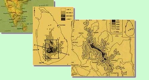
 

Baundaries


The Knuckles Mountain Range is bordered on the South and East by the Mahaweli river basin, and o the West by the Matale plains. They are lie separate from the rest of the Central Hills and exist as a unique ecosystem. 

Approach Roads


The Knuckles Mountain Range can be approached from

  • Matale via Rattota and the Bata Anduwa Kapolla(Reversten)

  • Kandy via Hunasgiriya and the Hulgan Kapolla (Corbert's Gap)

  • Wattegama via Panwita and Bambarella

  • LaggalaPallegama via Narangamuwa

  • Hasalaka via Barawardenaoya.
     

Nature Trails


  • IllukkumburaKosgaswala ( 2 kms from Illukkumbura)

  • Pitawala pathanapathanegama (3kms from Pathana)

  • ManigalaWalpolamullaDooveli Ella(8kms from Illukkumbura)

  • Corbepts Gap-ThangappuwaRanagala (8 kms from Corbets Gap)

  • KumbukgollaNitre Cave (8kms from Bambaraella)

  • Bambaraella-Selvakanda(8kms from Bambarella)

  • LakegalaMeemura(4kms from Tharangammuwa)


Google


WWW http://www.knucklesrange.org


Best view in IE 5.0 or above under 800x600 咀opyright 1996-2006. Mahendra Gunaratne 0777 783468  www.virusinc.org All rights reserved.