|
Cultivation of cardamom under the forest
canopy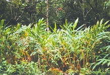 has become one of the major contributors for the
degradation of forest habitats in Knuckles Mountain Range.
This involves clearing of the shrubs and undergrowth
canopy trees. has become one of the major contributors for the
degradation of forest habitats in Knuckles Mountain Range.
This involves clearing of the shrubs and undergrowth
canopy trees.
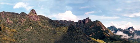
Further Cardamom cultivation is done over 3500 feet
elevation in the strict forest reserve, which covers about
2721 hectares. This cultivation has resulted in 21%
heavily degraded sites and 11% open canopy. 88 Barns are
found with in the Knuckles Range, which are used to dry
the Cardamom seeds before they have been send to the
market. The fuel wood for these barns are taken from
illegal felling of trees which is another contributory
factor for degradation of knuckles vegetation. According
to a survey conducted by Socio Environment Foundation
about 5000-6000 hectares in Knuckles Forests have been
damaged as a result of Cardamom cultivation and barns used
to dry the cardamom seeds.
Over grazing which is occurred by large herds of
domestic/feral cattle and buffalo. This can clearly be
seen in Pitawala patana plains in Knuckles range.
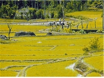 Over use of agricultural chemicals by farmers for paddy
cultivation also a one of the major threats, which can be
seen. An interview conducted with farmers showed that the
over usage of these chemicals occurs due to lack of
awareness. Over use of agricultural chemicals by farmers for paddy
cultivation also a one of the major threats, which can be
seen. An interview conducted with farmers showed that the
over usage of these chemicals occurs due to lack of
awareness.
Further those who visit Knuckles Mountain Range tend to
litter the non-biodegradable materials such as glass
bottles, plastic, and polythene into the environment
carelessly.
Illegal gem mining can be seen in certain areas of
Knuckles Range and this course for degradation of habitats
in these areas.
Hena cultivation and man-induced fires in hena land have
resulted in destruction of forest especially in the buffer
zone of the Knuckles. land have
resulted in destruction of forest especially in the buffer
zone of the Knuckles.
Spread of invasive alien species is also a threat to the
natural ecosystems, native wild plants and animals of
Knuckles Mountain Range. The common invasive alien plants
in the area include lantana (Lantana Camara),
koster’s curse (Clidemia Hirta) and wild
sunflower (Tithonia Diversifolia).
Direct exploitation of Species is also a major problem in
this area. Human activities such as illegal felling of
timber and fuel wood
 species and illegal hunting of animals
can be seen in this area. Further shooting animals or set traps guns and noose traps to kill animals, collection of
fish species from streams for the ornamental fish trade
and collecting of herbaceous plants for ornamental plant
trade are threats to the natural resources in this area.
Over collection of plants and animal species for
commercial purposes and research. /study purposes, course
a major thread, mainly to the endemic and threaded species
in the area. species and illegal hunting of animals
can be seen in this area. Further shooting animals or set traps guns and noose traps to kill animals, collection of
fish species from streams for the ornamental fish trade
and collecting of herbaceous plants for ornamental plant
trade are threats to the natural resources in this area.
Over collection of plants and animal species for
commercial purposes and research. /study purposes, course
a major thread, mainly to the endemic and threaded species
in the area.
|


 historical value it carries and therefore it can be
categorized as one of the valuable heritages in Sri Lanka.
The story of Knuckles (Dumbara Hill) goes back into
prehistoric periods. It is said that in ancient times it
was referred to as ‘Giri Divaina’ and as ‘Malaya
Rata’ and there is archaeological evidence that speaks
of ancient Yaksha settlement in the area. People
believe that the name ‘Lanka’ is derived which much
folklore has gathered over the centuries. The Knuckles
Mountain Range is an invariable referent in any salutary
appreciation of the last kingdom of the Sinhala Kanda
Udarata.
historical value it carries and therefore it can be
categorized as one of the valuable heritages in Sri Lanka.
The story of Knuckles (Dumbara Hill) goes back into
prehistoric periods. It is said that in ancient times it
was referred to as ‘Giri Divaina’ and as ‘Malaya
Rata’ and there is archaeological evidence that speaks
of ancient Yaksha settlement in the area. People
believe that the name ‘Lanka’ is derived which much
folklore has gathered over the centuries. The Knuckles
Mountain Range is an invariable referent in any salutary
appreciation of the last kingdom of the Sinhala Kanda
Udarata. 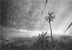 can be experienced within half and
hour walk through this valley. The location of the hills,
the particular effect of the monsoons and the wind factor
generate a certain climatic diversity to the area. In fact
in these hills one can find characteristics of all the key
ecological zones found in the country.
can be experienced within half and
hour walk through this valley. The location of the hills,
the particular effect of the monsoons and the wind factor
generate a certain climatic diversity to the area. In fact
in these hills one can find characteristics of all the key
ecological zones found in the country. 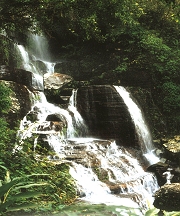 Southwest and Northwest Monsoons, the area enjoys
bountiful rainfalls. For this and other reasons, the
Knuckles Mountain Range is counted among the richer of the
upper watersheds in the country. In fact from these hills
flow the richer of the tributaries to the Mahaweli River.
Southwest and Northwest Monsoons, the area enjoys
bountiful rainfalls. For this and other reasons, the
Knuckles Mountain Range is counted among the richer of the
upper watersheds in the country. In fact from these hills
flow the richer of the tributaries to the Mahaweli River.
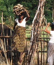
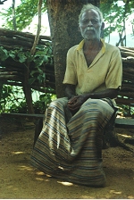 and Galamuduna are few villages
out of 37, which can be found in this area. Indigenous
community in this area has always interacted with and
depended upon the Knuckles Frosts and this association
goes as for back as prehistoric times. The day-to-day
lifestyle of this community are very simple and their main
income generating sources are farming, cultivation of
Paddy, and Hena, and Cardamom. These
villagers relay on cattle for transporting good between
villages an
and Galamuduna are few villages
out of 37, which can be found in this area. Indigenous
community in this area has always interacted with and
depended upon the Knuckles Frosts and this association
goes as for back as prehistoric times. The day-to-day
lifestyle of this community are very simple and their main
income generating sources are farming, cultivation of
Paddy, and Hena, and Cardamom. These
villagers relay on cattle for transporting good between
villages an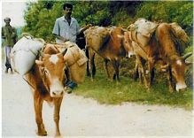 d sub-urban areas and this is referred as
Pack Ox (Thawalam). The traditional villagers
in this area maintain the rich cultural diversity
associated with unique natural landscape of Knuckles.
d sub-urban areas and this is referred as
Pack Ox (Thawalam). The traditional villagers
in this area maintain the rich cultural diversity
associated with unique natural landscape of Knuckles.